Difference between revisions of "Llanbedr, Brecknockshire"
From Wikishire
m |
(merge articles) |
||
| Line 1: | Line 1: | ||
| − | {{ | + | {{Infobox town |
| − | + | |name=Llanbedr | |
| − | '''Llanbedr''' is a small village | + | |county=Brecon |
| + | |picture=Llanbedr below Sugar Loaf - geograph.org.uk - 333839.jpg | ||
| + | |picture caption=Llanbedr from the west, with the Sugar Loaf behind | ||
| + | |os grid ref=SO239203 | ||
| + | |latitude=51.8768 | ||
| + | |longitude=-3.1062 | ||
| + | |population= | ||
| + | |census year= | ||
| + | |post town=Crickhowell | ||
| + | |postcode=NP8 | ||
| + | |dialling code=01873 | ||
| + | |LG district=Powys | ||
| + | |constituency=Brecon & Radnorshire | ||
| + | }} | ||
| + | '''Llanbedr''' is a small village in [[Brecknockshire]] two miles north-east of [[Crickhowell]]. It stands above the river known as the [[Grwyne Fechan]] just above its confluence with the [[Grwyne Fawr]] in the southern parts of the [[Black Mountains]] range. | ||
| − | The | + | The name 'Llanbedr' is Welsh for 'Peter's Church'; a common enough name. |
| − | + | The village sits within the shadow of Table Mountain, an outlying spur of [[Pen Cerrig-calch]] on which is perched the Iron Age hill fort of [[Crug Hywel]], from which Crickhowell takes its own name. | |
| − | + | ||
| + | The parish church is the Church of St Peter, a Grade II* listed building. | ||
==Outside links== | ==Outside links== | ||
| − | + | {{commons|Llanbedr, Crickhowell}} | |
| − | * | + | *{{geograph|5129532|Llanbedr}} |
| − | + | ==References== | |
| − | {{ | + | {{Reflist}} |
| + | [[File:Llanbedr church (geograph 2070726).jpg|left|thumb|200px|The Church of St Peter]] | ||
Revision as of 12:02, 23 February 2018
| Llanbedr | |
| Brecknockshire | |
|---|---|
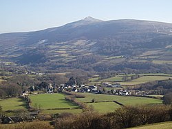
 Llanbedr from the west, with the Sugar Loaf behind | |
| Location | |
| Grid reference: | SO239203 |
| Location: | 51°52’36"N, 3°6’22"W |
| Data | |
| Post town: | Crickhowell |
| Postcode: | NP8 |
| Dialling code: | 01873 |
| Local Government | |
| Council: | Powys |
| Parliamentary constituency: |
Brecon & Radnorshire |
Llanbedr is a small village in Brecknockshire two miles north-east of Crickhowell. It stands above the river known as the Grwyne Fechan just above its confluence with the Grwyne Fawr in the southern parts of the Black Mountains range.
The name 'Llanbedr' is Welsh for 'Peter's Church'; a common enough name.
The village sits within the shadow of Table Mountain, an outlying spur of Pen Cerrig-calch on which is perched the Iron Age hill fort of Crug Hywel, from which Crickhowell takes its own name.
The parish church is the Church of St Peter, a Grade II* listed building.
Outside links
| ("Wikimedia Commons" has material about Llanbedr, Brecknockshire) |
