Warwickshire: Difference between revisions
| (9 intermediate revisions by 3 users not shown) | |||
| Line 2: | Line 2: | ||
|name=Warwickshire | |name=Warwickshire | ||
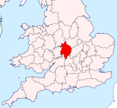
|map image=Warwickshire Brit Isles Sect 5.svg | |map image=Warwickshire Brit Isles Sect 5.svg | ||
|flag=Flag of Warwickshire.svg | |||
|picture=StratfordAvon20040717 CopyrightKaihsuTai.jpg | |picture=StratfordAvon20040717 CopyrightKaihsuTai.jpg | ||
|picture caption=Stratford-upon-Avon | |picture caption=Stratford-upon-Avon | ||
| Line 13: | Line 14: | ||
Warwickshire can boast of being the birthplace of the British imagination, for this is Shakespeare's own county. [[William Shakespeare]] was born in [[Stratford-upon-Avon]] in April 1564 and died there on 23 April 1616. Warwickshire has also produced other literary figures such as George Eliot (from [[Nuneaton]]), Rupert Brooke (from [[Rugby]]), and Michael Drayton from [[Hartshill]]. The poet Philip Larkin lived in Warwick (born in nearby Coventry), and Elizabeth Gaskell went to school in Barford and Stratford. | Warwickshire can boast of being the birthplace of the British imagination, for this is Shakespeare's own county. [[William Shakespeare]] was born in [[Stratford-upon-Avon]] in April 1564 and died there on 23 April 1616. Warwickshire has also produced other literary figures such as George Eliot (from [[Nuneaton]]), Rupert Brooke (from [[Rugby]]), and Michael Drayton from [[Hartshill]]. The poet Philip Larkin lived in Warwick (born in nearby Coventry), and Elizabeth Gaskell went to school in Barford and Stratford. | ||
There is more to the county though; Birmingham gained its place in the industrial revolution two hundred years after its place in the cultural revolution. | There is more to the county though; Birmingham gained Warwickshire its place in the industrial revolution two hundred years after its place in the cultural revolution. | ||
Stratford-on-Avon, the place of William Shakespeare's birth and of his death, has become a place of pilgrimage. His birthplace remains almost as he would have known it; a leaning half-timbered house, one of many in the town and in the villages of the neighbourhood, including the home of his wife, a large thatched, half-timbered house in beautiful country. Outside the town once stretched the Forest of Arden, an enchanted place which many celebrated, and though little woodland remains, the names of [[Hampton-in-Arden]] and [[Henley-in-Arden]] remain. The villages in this part of Warwickshire suggest what inspired the bard's sense of beauty. | Stratford-on-Avon, the place of William Shakespeare's birth and of his death, has become a place of pilgrimage. His birthplace remains almost as he would have known it; a leaning half-timbered house, one of many in the town and in the villages of the neighbourhood, including the home of his wife, a large thatched, half-timbered house in beautiful country. Outside the town once stretched the Forest of Arden, an enchanted place which many celebrated, and though little woodland remains, the names of [[Hampton-in-Arden]] and [[Henley-in-Arden]] remain. The villages in this part of Warwickshire suggest what inspired the bard's sense of beauty. | ||
North-west of Hampton-in-Arden is [[Solihull]], a pleasant town, but the opening of the Birmingham conurbation, and eastward the bands of motorways and great roads cut through the middle of what would otherwise be rich farmland and countryside. At the other end of the roads, at the centre of the county, is Coventry, once the centre of the motor car industry but a city of greater variety. [[Coventry]] was devastated by bombs during the Second World War and by the city corporation before and after it. | |||
[[Birmingham]] sits on the north-western part of Warwickshire. It is the second largest great city in Britain. Birmingham was built on heavy industry; it was known in its heyday as "the toyshop of the | [[Birmingham]] sits on the north-western part of Warwickshire. It is the second largest great city in Britain. Birmingham was built on heavy industry; it was known in its heyday as "the toyshop of the world". Birmingham is the centre also of the greatest network of canals in Britain, linking it not only with the industrial towns of the [[Black Country]] but also with the rest of the country. The whole area is rich in coal, the fuel of industry. Now Birmingham is a city constantly reinventing and redeveloping itself. Its many suburbs have a variety unique to the city. Birmingham long ago expanded beyond Warwickshire to cover the fields of [[Worcestershire]] and [[Staffordshire]] too. Birmingham now forms part of one big conurbation with the Black Country in Staffordshire and Worcestershire. | ||
==Geography== | ==Geography== | ||
Warwickshire is roughly rhomboid in shape, lying in the middlemost of the Midlands and surrounded by many Midland counties. Its north-eastern border is formed by [[Watling Street]], the old Roman Road which | [[FIle:Warwickshire Hundreds.svg|thumb|250px|The hundreds of Warwickshire]] | ||
Warwickshire is roughly rhomboid in shape, lying in the middlemost of the Midlands and surrounded by many Midland counties. Its north-eastern border is formed by [[Watling Street]], the old Roman Road which in King Alfred's day was established as the border between the English and the Danelaw. Across Watling Street is [[Leicestershire]]. To the north-west Warwickshire is bounded by [[Staffordshire]], to the south-east by [[Northamptonshire]], to the west by [[Worcestershire]]. To the south, [[Oxfordshire]] and [[Gloucestershire]] meet it. The northern tip of the county is only three miles from the [[Derbyshire]] border. | |||
It is divided into four hundreds: | |||
*[[Barlichway]] | |||
*[[Hemlingford]] (including those parts of Birmingham in Warwickshire) | |||
*[[Kington Hundred|Kington]] (including Warwick) | |||
*[[Knightlow]] (including Coventry) | |||
The majority of Warwickshire's population live in the north and centre of the county. The market towns of northern and eastern Warwickshire were industrialised in the 19th century, and include [[Atherstone]], [[Bedworth]], [[Nuneaton]], and [[Rugby]]. Major industries included coal mining, textiles, engineering, and cement production, but heavy industry is in decline, being replaced by distribution centres, light to medium industry, and services. Of the northern and eastern towns, only Nuneaton and Rugby (as the birthplace of rugby football) are well-known outside of Warwickshire. The prosperous towns of central and western Warwickshire including [[Leamington Spa]], [[Stratford-upon-Avon]], [[Kenilworth]], [[Alcester]], and [[Warwick]] harbour light to medium industries, services and tourism as major employment sectors. | The majority of Warwickshire's population live in the north and centre of the county, in the hundreds of Hemlingford and Knightlow. The market towns of northern and eastern Warwickshire were industrialised in the 19th century, and include [[Atherstone]], [[Bedworth]], [[Nuneaton]], and [[Rugby]]. Major industries included coal mining, textiles, engineering, and cement production, but heavy industry is in decline, being replaced by distribution centres, light to medium industry, and services. Of the northern and eastern towns, only Nuneaton and Rugby (as the birthplace of rugby football) are well-known outside of Warwickshire. The prosperous towns of central and western Warwickshire including [[Leamington Spa]], [[Stratford-upon-Avon]], [[Kenilworth]], [[Alcester]], and [[Warwick]] harbour light to medium industries, services and tourism as major employment sectors. | ||
The south of the county is largely rural and sparsely populated, and includes a small area of the [[Cotswold Hills|Cotswolds]], at the border with | The south of the county is largely rural and sparsely populated, and includes a small area of the [[Cotswold Hills|Cotswolds]], at the border with north-west Gloucestershire. There are no towns in the south of Warwickshire. The [[county top|highest point]] in the county, at 856 feet, is Ebrington Hill, again on the border with Gloucestershire, {{getmap|SP187426}} at the county's south-western extremity. | ||
The north of the county, bordering Staffordshire and Leicestershire, is mildly undulating countryside and the northernmost village, No Man's Heath looks 35 miles north towards the [[Peak District]]. | The north of the county, bordering Staffordshire and Leicestershire, is mildly undulating countryside and the northernmost village, No Man's Heath looks 35 miles north towards the [[Peak District]]. | ||
=== Arden and Felden === | === Arden and Felden === | ||
[[File:Hampton in Arden - Estate Cottages.jpg|right|thumb|200px|Estate cottages in | [[File:Hampton in Arden - Estate Cottages.jpg|right|thumb|200px|Estate cottages in Hampton-in-Arden]] | ||
Much of western Warwickshire, including that area now covered by the Birmingham conurbation, was covered by the ancient [[Forest of Arden]]. Most of the forest was hewn down to make fuel for industrialisation). Thus the names of a number of places in the | Much of western Warwickshire, including that area now covered by the Birmingham conurbation, was covered by the ancient [[Forest of Arden]]. Most of the forest was hewn down to make fuel for industrialisation). Thus the names of a number of places in the north-western part of Warwickshire end with the phrase "-in-Arden", such as [[Henley-in-Arden]], [[Hampton-in-Arden]] and [[Tanworth-in-Arden]]. The remaining area, not part of the forest, was called the Felden. | ||
===Shakespeare heritage=== | ===Shakespeare heritage=== | ||
| Line 58: | Line 66: | ||
===Cities=== | ===Cities=== | ||
[[File:Gas Street Basin in Birmingham - geograph.org.uk - 1736232.jpg|right|thumb|200px|Gas Street Basin, Birmingham]] | [[File:Gas Street Basin in Birmingham - geograph.org.uk - 1736232.jpg|right|thumb|200px|Gas Street Basin, Birmingham]] | ||
* [[Birmingham]] | * [[Birmingham]] (part, population 468,812) | ||
* [[Coventry]] | * [[Coventry]] | ||
| Line 87: | Line 95: | ||
*[[Studley, Warwickshire|Studley]] | *[[Studley, Warwickshire|Studley]] | ||
*[[Sutton Coldfield]] | *[[Sutton Coldfield]] | ||
* | *[[Tamworth]] ''(partly in [[Staffordshire]])'' | ||
*[[Warwick]] | *[[Warwick]] ''([[county town]])'' | ||
*[[Wellesbourne]] | *[[Wellesbourne]] | ||
*[[Whitnash]] | *[[Whitnash]] | ||
| Line 105: | Line 113: | ||
The towns of Warwickshire created a number of major transport routes, and later expanded on the strength of those routes. | The towns of Warwickshire created a number of major transport routes, and later expanded on the strength of those routes. | ||
The Grand Union Canal from Birmingham to London is a feature in much of the county. In and around Birmingham is a major canal network, built during the industrial revolution, as was the Coventry Canal. The heavy-laden barges have stopped coming and the canals are now enjoyed as a leisure facility. | The [[Grand Union Canal]] from Birmingham to London is a feature in much of the county. In and around Birmingham is a major canal network, built during the industrial revolution, as was the [[Coventry Canal]]. The heavy-laden barges have stopped coming and the canals are now enjoyed as a leisure facility. | ||
Five motorways carve their way through Warwickshire. Forming the route between London and Birmingham is the | Five motorways carve their way through Warwickshire. Forming the route between London and Birmingham is the [[M40 motorway|M40]]. The [[M6 motorway|M6]] runs east-west to the north of Birmingham, connecting the north-west of England and the Midlands to the [[M1 motorway|M1]], and part of the [[M6 Toll]] motorway passes through the county too. The [[M42 motorway|M42]] runs in an L-shape around Birmingham and Solihull from the M40; to the east joining the M40 to the M6 and to the south joining it to the [[M5 motorway|M5]]. The [[M69 motorway|M69]] joins Coventry to Leicester by way of Nuneaton. The [[M45 motorway|M45]] is a short spur south of Rugby connecting to the M1. | ||
Other major trunk routes join Coventry and Birmingham and cross between the county's major towns. | Other major trunk routes join Coventry and Birmingham and cross between the county's major towns. | ||
| Line 140: | Line 148: | ||
*[[Lord Leycester Hospital]], Warwick | *[[Lord Leycester Hospital]], Warwick | ||
*[[Lowsonford]] | *[[Lowsonford]] | ||
*[[ | *[[Mary Arden's House]], Wilmcote | ||
*{{i-Museum}} Midland Air Museum | *{{i-Museum}} Midland Air Museum | ||
*[[Oxford Canal]] | *[[Oxford Canal]] | ||
| Line 148: | Line 156: | ||
*[[Rugby]] School | *[[Rugby]] School | ||
*{{i-Park}} [[Ryton Pools]] Country Park | *{{i-Park}} [[Ryton Pools]] Country Park | ||
*{{i-Castle}} [[Tamworth Castle]] | |||
*{{i-Castle}} [[Warwick Castle]] | *{{i-Castle}} [[Warwick Castle]] | ||
*[[Shakespeare's Birthplace|William Shakespeare's Birthplace]] and related sites, Stratford-upon-Avon | |||
==References== | ==References== | ||
{{reflist}} | {{reflist}} | ||
{{British county}} | {{British county}} | ||
Latest revision as of 17:53, 3 July 2022
| Warwickshire United Kingdom | |
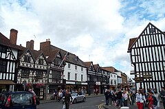 Stratford-upon-Avon | |
|---|---|

| |
| Flag | |
| United to serve | |
| |
| [Interactive map] | |
| Area: | 918 square miles |
| Population: | 1,632,885 |
| County town: | Warwick |
| Biggest town: | Birmingham |
| County flower: | Honeysuckle [1] |
The County of Warwick is a shire in the Midlands. Parts of the county are heavily urbanised, and in particular Birmingham and its suburbs form Britain's second city (albeit that Manchester in Lancashire contests the title), and Coventry to the east is another major centre.
The county town, from which the county takes its name, is Warwick, but its largest town by far is Birmingham, the heart of a vast conurbation spreading over much of Warwickshire, Staffordshire and Worcestershire.
Warwickshire can boast of being the birthplace of the British imagination, for this is Shakespeare's own county. William Shakespeare was born in Stratford-upon-Avon in April 1564 and died there on 23 April 1616. Warwickshire has also produced other literary figures such as George Eliot (from Nuneaton), Rupert Brooke (from Rugby), and Michael Drayton from Hartshill. The poet Philip Larkin lived in Warwick (born in nearby Coventry), and Elizabeth Gaskell went to school in Barford and Stratford.
There is more to the county though; Birmingham gained Warwickshire its place in the industrial revolution two hundred years after its place in the cultural revolution.
Stratford-on-Avon, the place of William Shakespeare's birth and of his death, has become a place of pilgrimage. His birthplace remains almost as he would have known it; a leaning half-timbered house, one of many in the town and in the villages of the neighbourhood, including the home of his wife, a large thatched, half-timbered house in beautiful country. Outside the town once stretched the Forest of Arden, an enchanted place which many celebrated, and though little woodland remains, the names of Hampton-in-Arden and Henley-in-Arden remain. The villages in this part of Warwickshire suggest what inspired the bard's sense of beauty.
North-west of Hampton-in-Arden is Solihull, a pleasant town, but the opening of the Birmingham conurbation, and eastward the bands of motorways and great roads cut through the middle of what would otherwise be rich farmland and countryside. At the other end of the roads, at the centre of the county, is Coventry, once the centre of the motor car industry but a city of greater variety. Coventry was devastated by bombs during the Second World War and by the city corporation before and after it.
Birmingham sits on the north-western part of Warwickshire. It is the second largest great city in Britain. Birmingham was built on heavy industry; it was known in its heyday as "the toyshop of the world". Birmingham is the centre also of the greatest network of canals in Britain, linking it not only with the industrial towns of the Black Country but also with the rest of the country. The whole area is rich in coal, the fuel of industry. Now Birmingham is a city constantly reinventing and redeveloping itself. Its many suburbs have a variety unique to the city. Birmingham long ago expanded beyond Warwickshire to cover the fields of Worcestershire and Staffordshire too. Birmingham now forms part of one big conurbation with the Black Country in Staffordshire and Worcestershire.
Geography

Warwickshire is roughly rhomboid in shape, lying in the middlemost of the Midlands and surrounded by many Midland counties. Its north-eastern border is formed by Watling Street, the old Roman Road which in King Alfred's day was established as the border between the English and the Danelaw. Across Watling Street is Leicestershire. To the north-west Warwickshire is bounded by Staffordshire, to the south-east by Northamptonshire, to the west by Worcestershire. To the south, Oxfordshire and Gloucestershire meet it. The northern tip of the county is only three miles from the Derbyshire border.
It is divided into four hundreds:
- Barlichway
- Hemlingford (including those parts of Birmingham in Warwickshire)
- Kington (including Warwick)
- Knightlow (including Coventry)
The majority of Warwickshire's population live in the north and centre of the county, in the hundreds of Hemlingford and Knightlow. The market towns of northern and eastern Warwickshire were industrialised in the 19th century, and include Atherstone, Bedworth, Nuneaton, and Rugby. Major industries included coal mining, textiles, engineering, and cement production, but heavy industry is in decline, being replaced by distribution centres, light to medium industry, and services. Of the northern and eastern towns, only Nuneaton and Rugby (as the birthplace of rugby football) are well-known outside of Warwickshire. The prosperous towns of central and western Warwickshire including Leamington Spa, Stratford-upon-Avon, Kenilworth, Alcester, and Warwick harbour light to medium industries, services and tourism as major employment sectors.
The south of the county is largely rural and sparsely populated, and includes a small area of the Cotswolds, at the border with north-west Gloucestershire. There are no towns in the south of Warwickshire. The highest point in the county, at 856 feet, is Ebrington Hill, again on the border with Gloucestershire, SP187426 at the county's south-western extremity.
The north of the county, bordering Staffordshire and Leicestershire, is mildly undulating countryside and the northernmost village, No Man's Heath looks 35 miles north towards the Peak District.
Arden and Felden
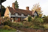
Much of western Warwickshire, including that area now covered by the Birmingham conurbation, was covered by the ancient Forest of Arden. Most of the forest was hewn down to make fuel for industrialisation). Thus the names of a number of places in the north-western part of Warwickshire end with the phrase "-in-Arden", such as Henley-in-Arden, Hampton-in-Arden and Tanworth-in-Arden. The remaining area, not part of the forest, was called the Felden.
Shakespeare heritage
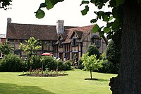
Stratford-upon-Avon is a town now filled in the summer with visitors, but which has not lost its charm. The Royal Shakespeare Company have three theatres in Stratford; The Royal Shakespeare Theatre, The Swan and The Courtyard Theatre.[1]
The Shakespeare Birthplace Trust own a number of properties in and around Stratford connected with William Shakespeare, all within an easy walk of the town:
- Shakespeare's Birthplace Museum
- Anne Hathaway's Cottage, Shottery
- Hall's Croft (cottage of their daughter, Suzanna)
- Mary Arden's House (Glebe Farm), Wilmcote
- Palmer's Farm (formerly believed to be Mary Arden's House)
- Nash's House and New Place

Towns and cities
There are two cities in Warwickshire; Coventry and Birmingham. Birmingham is Britain's second city and the kernel of a vast conurbation. Coventry, due east of Birmingham, is in the centre of Warwickshire. The two are linked by motorways and A-roads slicing across the intervening countryside.
The home of Warwickshire County Cricket Club is at Edgbaston near Birmingham, a meadow of calm beside the clamour of the city.
The town of Tamworth in Staffordshire spreads across the county boundary so that about half of its area, its eastern suburbs, are within Warwickshire.
The largest towns in Warwickshire after Birmingham and Coventry are Solihull (pop. 94,753), Nuneaton (77,500), Rugby (62,700), Leamington Spa (45,300), and Bedworth (32,500).
Cities
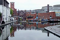
- Birmingham (part, population 468,812)
- Coventry
Larger towns
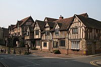
History

The first reference to Warwickshire as such was in 1001, as Wæringscir named after Warwick (meaning "weir village").
During the Middle Ages Warwickshire was dominated by Coventry, which was at the time one of the most important cities in England due to its textiles trade in the heart of England. Warwickshire played a key part in the English Civil War, with the Battle of Edgehill and other skirmishes taking place in the county. During the Industrial Revolution Warwickshire became one of Britain's foremost industrial counties, with the large industrial cities of Birmingham and Coventry within its boundaries.
Transport
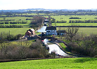

The towns of Warwickshire created a number of major transport routes, and later expanded on the strength of those routes.
The Grand Union Canal from Birmingham to London is a feature in much of the county. In and around Birmingham is a major canal network, built during the industrial revolution, as was the Coventry Canal. The heavy-laden barges have stopped coming and the canals are now enjoyed as a leisure facility.
Five motorways carve their way through Warwickshire. Forming the route between London and Birmingham is the M40. The M6 runs east-west to the north of Birmingham, connecting the north-west of England and the Midlands to the M1, and part of the M6 Toll motorway passes through the county too. The M42 runs in an L-shape around Birmingham and Solihull from the M40; to the east joining the M40 to the M6 and to the south joining it to the M5. The M69 joins Coventry to Leicester by way of Nuneaton. The M45 is a short spur south of Rugby connecting to the M1.
Other major trunk routes join Coventry and Birmingham and cross between the county's major towns.
Warwickshire has two airports: Birmingham International Airport and Coventry Airport, in Baginton.
Places of interest
| Key | |
| Cathedral/Abbey/Priory | |
| Accessible open space | |
| Amusement/Theme Park | |
| Castle | |
| Country Park | |
| English Heritage | |
| Forestry Commission | |
| Heritage railway | |
| Historic House | |
| Museum (free/not free) | |
| National Trust | |
| Zoo | |
 Arbury Hall
 Battle of Edgehill site
 The Belfry
- Birmingham Canals
 Brinklow Castle
- Burton Dassett Hills
 Charlecote Park
 Compton Verney House
 Compton Wynyates
 Coombe Abbey
 Coombe Country Park
 Coughton Court
- Coventry Canal
- Draycote Water
- Grand Union Canal
- Guy Fawkes House (Dunchurch)
 Hartshill Hayes County Park
 Heritage Motor Centre, Gaydon
- The James Gilbert Rugby Football Museum
 Kenilworth Castle
 Kingsbury Water Park
 Ladywalk Reserve
- Lunt Roman Fort
- Lord Leycester Hospital, Warwick
- Lowsonford
- Mary Arden's House, Wilmcote
 Midland Air Museum
- Oxford Canal
 Ragley Hall
- River Avon
- Rugby Art Gallery and Museum
- Rugby School
 Ryton Pools Country Park
 Tamworth Castle
 Warwick Castle
- William Shakespeare's Birthplace and related sites, Stratford-upon-Avon
References
| Counties of the United Kingdom |
|---|
|
Aberdeen • Anglesey • Angus • Antrim • Argyll • Armagh • Ayr • Banff • Bedford • Berks • Berwick • Brecknock • Buckingham • Bute • Caernarfon • Caithness • Cambridge • Cardigan • Carmarthen • Chester • Clackmannan • Cornwall • Cromarty • Cumberland • Denbigh • Derby • Devon • Dorset • Down • Dumfries • Dunbarton • Durham • East Lothian • Essex • Fermanagh • Fife • Flint • Glamorgan • Gloucester • Hants • Hereford • Hertford • Huntingdon • Inverness • Kent • Kincardine • Kinross • Kirkcudbright • Lanark • Lancaster • Leicester • Lincoln • Londonderry • Merioneth • Middlesex • Midlothian • Monmouth • Montgomery • Moray • Nairn • Norfolk • Northampton • Northumberland • Nottingham • Orkney • Oxford • Peebles • Pembroke • Perth • Radnor • Renfrew • Ross • Roxburgh • Rutland • Selkirk • Shetland • Salop • Somerset • Stafford • Stirling • Suffolk • Surrey • Sussex • Sutherland • Tyrone • Warwick • West Lothian • Westmorland • Wigtown • Wilts • Worcester • York |