Watlington, Oxfordshire: Difference between revisions
mNo edit summary |
|||
| Line 52: | Line 52: | ||
==Big Society== | ==Big Society== | ||
[[File:High Street, Watlington - geograph.org.uk - 1369470.jpg|right|thumb| | [[File:High Street, Watlington - geograph.org.uk - 1369470.jpg|right|thumb|200px|Watlington High Street]] | ||
[[The Ridgeway]] National Trail walking route, which forms part of the longer [[Icknield Way]], passes southeast of the town along the top of the Chiltern Hills. | [[The Ridgeway]] National Trail walking route, which forms part of the longer [[Icknield Way]], passes southeast of the town along the top of the Chiltern Hills. | ||
Latest revision as of 21:47, 24 September 2014
| Watlington | |
| Oxfordshire | |
|---|---|
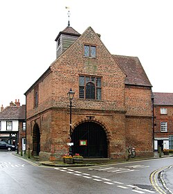
 Watlington Town and Market Hall | |
| Location | |
| Grid reference: | SU687945 |
| Location: | 51°38’42"N, 1°0’29"W |
| Data | |
| Population: | 2,403 (2001) |
| Post town: | Watlington |
| Postcode: | OX49 |
| Dialling code: | 01491 |
| Local Government | |
| Council: | South Oxfordshire |
| Parliamentary constituency: |
Henley |
| Website: | Watlington Parish Council |
Watlington is a small market town in Oxfordshire found about 7 miles south of Thame. The parish includes the hamlets of Christmas Common and Greenfield, both of which are in the Chilterns. The M40 motorway is about 2½ miles from Watlington.
The name of the town means "Village of Wæcel's people".
Churches
- Church of England: St Leonard's – the Norman and mediæval parish church, restored in 1877
- Methodist: Watlington Methodist Church, built 1812, replacing the earlier Wesleyan chapel
- Roman Catholic: St Edmund Campion (named after a convert Jesuit priest executed at Tyburn for sedition in 1581). This church replaced the earlier Church of the Sacred Heart (1930).
The parish church is St Leonard. It contains remnants of a Norman church, including a diapered tympanum that was over the north door until this was dismantled for the building of the north aisle. The church was extensively rebuilt in the 14th century, and the arcade of the south aisle survives from this period.[1] The south chapel is 15th century, built for Maud Warner as a memorial for her husband Richard, a woolman.[2] The tower is also Mediæval. A few Decorated Gothic and Perpendicular Gothic windows survive, but in the restoration in 1877 some were moved to different positions within the church.
In 1763 Edward Horne, a local landowner, obtained permission to build a burial vault east of the Warner chapel and south of the chancel.[2] In 1877 the church underwent an extensive restoration by the architects H J Tollit and Edwin Dolby restored the church. [1]
St. Leonard's parish is now part of the Benefice of Icknield.[3]
During the 17th and 18th centuries several nonconformist denominations existed in Watlington, with Quakers, Baptists and Seventh Day Baptists most prominent in different periods. Methodist preachers visited Watlington by invitation from 1764, with John Wesley himself preaching in the town in 1766, 1774 and 1775. The Wesleyan chapel was built in 1796.[2] The current church was built in 1812, and it is now part of the Oxford Methodist Circuit.[4]
History
The Watlington area is likely to have been settled at an early date, encouraged by the proximity of the Icknield Way. Its name is Old English and an analysis of similar names suggests an origin around the 6th century. A 9th-century charter by Æthelred, Ealdorman of Mercia mentions eight 'manses' or major dwellings in Watlington.[2]
The Domesday Book of 1086 identified the area as an agricultural community valued at £610. Mediæval documents indicate that the modern street plan was in existence in the 14th century, if not earlier. Cochynes-lane (Couching Street), and Brook Street are recorded and the High Street must have had houses.
There are records of inns in Watlington since the 15th century. In 1722 the town's market was listed as being held on a Saturday.[5] By the end of the 18th century the town had six inns, all of which were bought up in the next few years by a local brewing family, the Haywards. The number of licenced premises increased until late in the 19th century when George Wilkinson, a Methodist bought six of them and closed them down. Today Watlington has three public houses: the Carriers Arms, the Chequers and The Fat Fox Inn (which is been said to be one of the best gastro-pub in Oxfordshire) .[6]
Parliamentarian troops were billeted at Watlington during the Civil War. It is thought that John Hampden stayed in the town the night before the Battle of Chalgrove Field.[7]
In 1664-65 the Town Hall was built at the expense of Thomas Stonor. Its upper room was endowed by Stonor as a grammar school for boys, and in 1731 Dame Alice Tipping of Ewelme gave a further endowment to increase the number of pupils. In 1842 the town Vestry established a National School, which shared the same rooms in the Town Hall. In 1843 a National School for girls was built next to St. Leonard's church. In 1872 the boys' and girls' schools were absorbed into a new Board school, which like its predecessors was affiliated to the National Society for Promoting Religious Education. In 1927 the school was divided into separate junior and senior schools. In 1956 a new secondary school - the Icknield School - opened for senior pupils and the primary school took over the old premises.[8] The Icknield School is now Icknield Community College.[9]

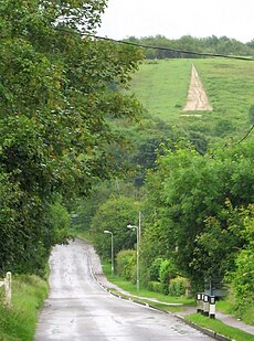
The Watlington White Mark is a chalk-cut shape in the hill by Watlington resembling a church spire. It was designed by local squire Edward Horne for reasons not quite known but it is said that he felt that the parish church of St Leonard, when viewed from his home, would be more impressive if it appeared to have a spire, so he had this unusual folly cut into the chalk escarpment of Watlington Hill in 1764. It is 36 feet wide at its base and 270 feet long.[2]
In 1872 the Watlington and Princes Risborough Railway was opened. Its Watlington terminus is in fact in Pyrton parish, half a mile from Watlington. In 1883 the Great Western Railway took over control of the line.[10] In 1957 British Railways closed Watlington station and withdrew all passenger services between Watlington and Chinnor, which was still being used by the local Chinnor Cement Works. In 1961 all services ceased on the line, the track was lifted and the line left abandoned. The Watlington railway station site remains, as does the station building, the corriagted iron carriage shed, and the brickwork of the goods shed. The line served the people of Watlington and the surrounding villages for 89 years.
By 1895 the Town Hall, no longer used as a school, was in disrepair. In 1907 it was restored by public subscription. It forms a landmark at the meeting point of three roads in the centre of the town.
Big Society

The Ridgeway National Trail walking route, which forms part of the longer Icknield Way, passes southeast of the town along the top of the Chiltern Hills.
Watlington has a Women's Institute.[11]
Watlington Cricket Club[12] first eleven plays in Oxfordshire Cricket Association league division two.[13]
Outside links
References
- ↑ 1.0 1.1 Sherwood, Jennifer; Pevsner, Nikolaus (1974). Oxfordshire. The Buildings of England. Harmondsworth: Penguin Books. pp. 829–832. ISBN 0-14-071045-0.
- ↑ 2.0 2.1 2.2 2.3 2.4 A History of the County of Oxford: Volume 8: Lewknor and Pyrton Hundreds - Victoria County History, 1964
- ↑ Benefice of Icknield: St Leonard's Church, Watlington
- ↑ [ http://www.oxfordmethodists.org.uk/index.php/watlington Oxford Methodist Circuit - Watlington]
- ↑ Stow, W. (1722). Remarks on London, being an Exact Survey of the Cities of London and Westminster, Borough of Southwark. London. http://www.londonancestor.com/stow/stow-market-all.htm. Retrieved 20 September 2010.
- ↑ Watlington Parish Council: Watlington Food & Drink
- ↑ Nugent-Grenville, George (1854). Some memorials of John Hampden: his party and his times. London: Chapman & Hall. p. 359.
- ↑ Watlington Primary School
- ↑ Icknield Community College
- ↑ Chinnor and Princes Risborough Railway: History
- ↑ Oxfordshire Federation of Women's Institutes
- ↑ Watlington Cricket Club
- ↑ Oxfordshire Cricket Association
- Oppitz, Leslie (2000). Lost Railways of the Chilterns. Newbury: Countryside Books. pp. 20–23. ISBN 1-85306-643-5.